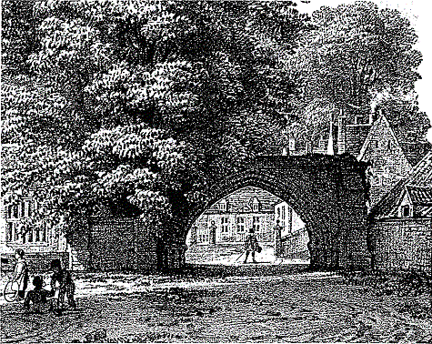
The Arch and Tithe Barn
Although the Arch and Tithe Barn form part of Repton School, the view of the the Arch is so closely linked with that of St Wystan's Church, that we have taken the liberty of including them here. What follows is an article by Professor Martin Biddle writing in the Derbyshire Archaeological Journal, date unknown but about 1990. Unfortunately, it has not been possible to reproduce Samuel Buck's sketch of 1727.
The Arch
Since the foundation of Repton School in 1557, the Arch has been the entrance not only to the School, but to the proper life. The School's motto, Porta vacat culpa, 'The gate is free from blame', plays, in half a line from Ovid (Fasti II.204), both on the Arch and on the name of the founder, Sir John Port of Etwall who died in 15571.
The Arch was built in the thirteenth century as the outer element of the gatehouse of the Augustinian priory founded by Matilda, countess of Chester, in 1159.2 General belief seems to have held that the body of the gatehouse was knocked down in the demolition of the priory buildings by Gilbert Thacker in the mid-1550s.3 However, a drawing recently discovered in the Bodleian Library at Oxford shows the gatehouse still standing in 1727. The Bodleian view was probably drawn by Samuel Buck in June or July 1727, for it is framed and titled in the manner of the topographical engravings of the brothers Buck, and on the back there is a sketch of 'The West View of Mackworth Castle', with the note 'Sam. Buck delint June 27th 1727'. Mackworth is seven miles north of Repton and was probably visited on the same tour. The Repton view is titled 'The South View of Repton Abbey four miles South from Derby. 1727', but it shows in detail only the gatehouse. Through the Arch can be seen the faint outlines of the 'Free School' and 'Madm. Thacker's House'. The first is what is now known as The Old Priory, the surviving west range of the priory purchased by Sir John Port's executors and converted into the 'free school' of his intention in 1557.4 The second is The Hall, now the headmaster's house, but until 1729 still in the ownership of the last of the Thackers, Mary (1658-1729), here called 'Madam Thacker'.5 Between the two windows over the Arch on the drawing there is an achievement of arms. This the Bucks would subsequently have drawn out on a larger scale, to judge by their usual practice, below the curved portion of the line below the drawing, at the centre of the space reserved for an engraved text setting out the history and ownership of the place depicted. Although the buildings are here drawn in pencil with wash over, the arms are picked out in ink. They cannot be identified on the drawing, but Dr Simon Degge recorded in his journal in July 1726 that they were 'in Bass Releif' and were the 'paternal coat of the Thackers a maiden lady of the family [i.e. Mary Thacker] being the Lady of the Mannor'.6 These arms were granted to Thomas Thacker in May 1538, shortly before he acquired a lease of the suppressed priory. It may well have been Thomas who erected this coat in bas relief above the entrance to his new seat.'
What is interesting, in view of the importance of the Arch in the history and image of the School, is that the arms on the gatehouse were those of Thacker and not Port. In fact the gatehouse was not sold to Sir John Port's executors in 1559, although right of way through it appears to have been silently included in the phrase 'all the paths and ways coming or leading to' the property then purchased. In 1670 an agreement drawn up between the Thackers and the School specifically reserved the School Yard 'for the public use of both parties and not ... for any other or private use whatsoever', and described its southern limit as 'the Structure called Mr. Thacker's Great Gate House'. It was not apparently until 1891, long after the gatehouse had been demolished, that its site was finally acquired by the School.8 When and why the gatehouse was demolished remain unclear. It had gone by 1829 when the Tithe Barn adjacent to the Arch is alone shown on Richard Benton's parish map of that date.9 It had probably gone by 1790 when Stebbing Shaw mentions only 'a large plain pointed Arch, which leads into the Priory ground, now called the Schoolyard; from this arch or gate way extends a high and massy stone wall towards the town ...'.10 Stebbing Shaw (1762-1802) was educated at Repton in the years before 1780 and would probably have mentioned the gatehouse had he ever seen it. Its ruins may have remained standing for some considerable time. An enclosed area north of the Tithe Barn on Benton's map of 1829 may have been defined by the remains of the east side of the gate passage and the east wall of the eastern 'lean-to'; and the north limit of this area may indicate the line of the north face of the gatehouse. The east wall of the gate passage may even have stood in part until the construction of the School Marshal's Lodge in 1896. An ashlar wall on this line can be seen through the Arch on photographs taken before 1869 when the Old Fives Court which lay at the north end of the Tithe Barn on the east side of the wall was rebuilt and roofed.11 Before the rebuilding, as an early photograph now at the School shows, the southern end of this wall rose sharply in a series of set offs against the north side of the Arch. With a parallel wall to the east which can be seen rising at a similar angle to a considerable height at the north end of the Tithe Barn on a water colour painted before 1861, these two walls formed the normal heightened end of an open fives court.12
The Arch as it stands today preserves only the lower storey of the central part of the south face of the original gatehouse. The two buttresses flanking the Arch survive, apparently cut down and remodelled. The wall running east from the eastern buttress may survive in the north wall of the Tithe Barn, but no certain trace of it can be seen. The wall flanking the western buttress runs west to end in a similar buttress which marks the south-west corner of the original gatehouse. From here the wall runs north, now serving as the southern part of the churchyard wall, but originally forming the west wall of the gatehouse. Five buttresses still survive on the west face, the two southern ones appearing as pencil outlines on Buck's drawing. Inside the Arch the stubs of the side walls of the gate passage still survive at ground level. There is just enough detail at the junction of the west wall with the jamb of the Arch to show that there was originally a stone bench on the passage side of the wall: presumably there were originally benches along both sides of the gate passage. No other internal details survive; there is, in particular, no trace on the east face of the churchyard wall (the original west wall of the gatehouse) of the return of the rear, north, face of the gatehouse. As noted above, the line of this face may be preserved in a boundary shown on Benton's map of 1829. The rear arch of the gatehouse is shown on Buck's drawing as a rounded wash frame to the view of the School and Hall beyond.
 These few surviving fragments and the Buck drawing provide just enough evidence to reconstruct the appearance of the gatehouse before its demolition. The roof seems to have been remodelled at some late stage, possibly after the Dissolution: the two, late- or post-medieval windows lightly pencilled in by Buck above and between the buttresses on the west side of the gatehouse seem to have been truncated by the line of the roof as he saw it. The windows above the Arch also look late, so it may be that the upper floor and roof were reconstructed, perhaps when the Thackers added their arms to what was now the main entrance to their principal house. The details of the Arch suggest that the gatehouse was originally built in the mid-thirteenth century. The Arch consists of three chamfered orders springing from jambs composed of a large semi-circular shaft flanked on either side by nooked shafts separated by chamfer mouldings. The capitals and bases are similar to those of the crossing tower of the priory church, datable to the mid-thirteenth century.13 The bases have been much restored, and the buttresses have been remodelled from ground level at least once and possibly twice.14 The chamfered plinths of both main buttresses indicate clearly the much smaller projection from the wall face of the original buttressing, and it is this, with fewer set offs than today, which seems to be shown on the Buck drawing. Their present form, with many set offs, must date from after the demolition of the gatehouse, when the buttresses were probably also thickened. This was done to give better support to the now free-standing rectangular section of the wall containing the Arch, for this already had a pronounced lean outwards, as the stonework added to the buttress reveals.
Two points remain. First, the two northern buttresses on the west face of what is now the churchyard wall suggest that some structure continued northwards along the east side of the wall. Second, the east face of the large rebuilt buttress east of the Arch, above the level of the present tiled roof of the Tithe Barn, is roughly formed in such a way as to suggest that it originally lapped over the coped top of the precinct wall where it joins the gatehouse. Buck shows a line of trees beyond the wall and also shows the south-east comer of the gatehouse as if it joins the top of the wall. This seems to be a confusion, for it makes the drawing suggest that the wall runs off to the east, whereas it has certainly run due south on its present line since it was built in the thirteenth century. Buck stops the vertical line of the southeast corner of the gatehouse at the top of the precinct wall. This is correct, for the wall would have obscured the lower part of the corner. But he fails to continue the precinct wall across to join the buttress east of the Arch, where it still joins the remains of the gatehouse today.
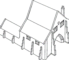
The Tithe Barn
Buck does not show the Tithe Barn. Had it existed in 1727, neither the trees behind the wall nor the greater part of the south-east corner of the gatehouse would have been visible from his viewpoint. It seems therefore that the Tithe Barn must have been put up after Buck's visit in 1727. It must also have been built after the rebuilding of the eastern buttress of the gatehouse which, as noted above, originally lapped over the coping of the precinct wall removed here when the Barn was built. The Barn was standing by 1825-9 when it appears on Benton's and Crabtree's maps15, but its date of construction is unknown. Stebbing-Shaw in 1790 and Bigsby in 1854 do not mention it, probably because they did not regard it as an old building. In the 1860s and 1870s it was simply 'the barn' or 'the Barn'.16 The name 'Tithe Barn' looks very much like a piece of recent, perhaps late-nineteenth century, antiquarian speculation.
The construction of the barn made use of the existing precinct wall, the coping of which was removed down the length of the building. The roof trusses, with their raking struts, generally light timbering, and absence of wind braces, indicate a post-medieval date; so does the brick infilling of the framing of the south gable, although this has been at least partly replaced. Some of the roof timbers, notably the tie-beams, are reused and were probably taken from a medieval structure. The demolition of the adjacent gatehouse between 1727 and 1790 may have provided materials for the construction of the 'Tithe Barn' in those years, but it could have been built even later.17 It first appears on the maps of 1825-29 and in a pencil drawing of June 1832. This drawing shows the barn with three cross-shaped loops in the south gable wall, two gabled dormers, and a thatched roof. By the time of M. Webster's lithograph of c. 1832-42 it had been tiled.
Acknowledgements
I am grateful to the Governors of the School and to the headmaster, Mr G.E. Jones, for granting access to the School's deeds, to the bursar, Brigadier P.F.B. Hargrave C.B.E., for his help in arranging for their transfer to Repton, and to Mr Ian Kitching who made an abstract of title from which the details in nn. 5 and 8 are taken. Dr R.K. Morris, University of Warwick, commented on the mouldings and the date of the Arch, and on the development of the buttresses. The research on which this article is based was undertaken as part of a project of architectural and archaeological investigation into the origins and development of Repton, its church, priory, and school, begun in 1974 under the joint direction of Dr H.M. Taylor, Mag. art., Birthe Kjølbye-Biddle, and myself. The work has been supported by generous grants from the Avenue Foundation, the British Academy, British Coal, Earthwatch: the Centre for Field Research, the Idlewild Trust, the Robert Kiln Trust, The National Westminster Bank, the Pilgrim Trust, the Society of Antiquaries, the volunteers of the Repton project; and by public donation.
Notes and References
- A. Macdonald, A Short History of Repton (London, 1929), 79-87, 189, who identifies the motto as a 'brilliant nineteenth century improvisation'. The reference is to the Porta Carmentalis, next to the Temple of Janus in Rome, the right-hand arch of which was thought to be unlucky (J.G. Frazer, Ovid's Fasti (Loeb Classical Library, London/New York, 1931), 72-3). The second half of Ovid's line, 'sed tamen omen habet' , 'but still it's ominous', may sometimes have been appreciated by some of Repton's less engaged classicists.
- For the date, see H.M. Colvin, ' Calke Priory', DAJ, 102 (1982),102-5; the relevant charters have been edited by G. Barraclough, The Charters of the Anglo-Norman Earls of Chester c. 1071 - 1237 (The Record Society of Lancashire and Cheshire, Manchester/Gloucester, 1988), nos. 119-22.
- For Gilbert and the demolition of the priory, see MacDonald, op. cit., 53.
- For the Old Priory and some of its many vicissitudes, see ibid., 88- 91, 321-7.
- The baptism (6 Jan. 1657/8) and burial (20 Jan. 1728 / 9) of Mary Thacker are recorded in the Repton parish registers. On her death the Hall passed to the Burdetts, from whom the School rented it in 1768 and finally purchased the property in 1891.
- Degge's autograph extract from his journal for 15 July 1726 is in the Royal Society, MS. EL. D.2.47. The phrase quoted is crossed out and does not appear in the published version of Degge's communication in Philosophical Transactions 35 (1727-8), 363-5. For Simon Degge M.D., F.R.S., F.S.A. (1694-1729) and his note in Philosophical Transactions, see M. Biddle et al., 'A Parcel of Pennies from a Mass-burial Associated with the Viking Wintering at Repton in 873-4', in M.A.S. Blackburn (ed.), Anglo-Saxon Monetary History (Leicester, 1986), 111-24, at 111-15.
- For the Thacker arms see R. Bigsby, Historical and Topographical Description of Repton (London, 1854), 96-8. They were gules, on fess azure, between three mascles argent, gutte sable, a trefoil azure, stalked vert, between two cranes heads erased proper, collar'd or; crest: a heron in a bed of rceds proper. They can be seen in St Wystan's Church on the memorials of Elizabeth Thacker (d.1684) and her brother-in-law Francis (d.1710) in the north aisle, and the mascles, which are the main element visible on the Buck drawing, appear on the grave slab of Gilbert Thacker (d.1563) against the south wall of the south aisle.
- For the extent of the purchase of 1559, see MacDonald, op. cit., 88. The agreement of 1670 survives in a draft kept in a portfolio of papers relating to the dispute with the Thackers now in Sir John Port's Chest in the School Library. For the later history of the lease and purchase, see P.C. Cooper-Parry, Sir John Port's Charity. Repton School. Property Register Compiled to 30th September 1925 (privately printed for the Governors, Derby, 1925), fos. 36-37.
- Derbyshire Record Office (D.R.O.), D 638A/PO 588; cf. D.R.O., D 2375M/170/5/1 and D 2375M/71/ 15. The same situation is shown on Richard Crabtree's map of 1825, formerly in the Burdett Estate Office at Foremarke, but at present lost, a Victorian tracing of the priory part of which now survives in the School.
- Stebbing Shaw, 'The History of Repton Priory, and Town, in Derbyshire', The Topographer, 2 (1790), 249-85, at 283. Much the same statement is made by 'Reptonensis' in 'The old Priory, and modern School, of Repton', The Gentleman's Magazine , 81.i (Jan.-June 1811), 105-6: the 'entrance from the village to the Monastery is through a gateway with a Pointed arch, into the School-yard (formerly called the Infirmary-yard)'.
- 'Modern Archaeology', The Reptonian, 12 (Nov. 1869), 274-7. Later photographs show the brick gable of the 1869 fives court rising beside the Arch above the north end of the Barn. For a further description of the pre-1869 fives court, see Item 22 in the letter of H. V. Peirs referred to in n. 16. This fives court must originally have been built after the drawing of the view of the Arch shown in Plate 3, for the V-shaped space between the east side of the Arch and the gable of the Barn had not then been filled with low brickwork to form the end wall of the pre-1869 court.
- This is a view looking north-west towards the School and church from beyond the far side of what is now the Upper Paddock. It does not show the 'New Schoolrooms' (now the stone block containing classrooms 9-12), the ground floor of which was built in 1861. The first floor, reached by Jacob's Ladder, was added in 1864, as a date stone over the gable of the Ladder confirms: see 'Modem Archaeology' (n. ll), 275.
- The dating proposed by W.H. St.J. Hope in what was one of his earliest published papers needs of revision, and greatly oversimplifies the structural development of the church: 'Repton Priory', DAJ 6 (1884),75-96; 'On the Augustinian Priory of the Holy Trinity, at Repton, Derbyshire', ibid. 7 (1885), 154-61; 'Repton Priory, Derbyshire', Archaeological Journal, 41 (1885), 349-69. For a more recent view, see N. Pevsner, Derbyshire, The Buildings of England (Harmondsworth, 2nd ed., 1978), 3038. For further discoveries by W.A. Forsyth during the refurbishment of the old Priory and the creation of the War Memorial Cloister in 1922, see A.H. Thompson, 'Recent Excavations at Repton Priory', DAJ, 45 (1923),14-23.
- The ground level below the Arch had risen greatly by the 1830s, as 19th-century views show. Early photographs show that it had been lowered by the 1860s. The ground was reduced to its present level in 1920 at a cost of £200: Outline History of Sir John Port's Charity (Repton, privately printed for the School, n.d. but c. 1924).
- See above, n. 9.
- 'Modern Archaeology' (as n. ll); H.R. Huckin, A Letter to the Governing Body of Repton School (privately printed, 1874; a copy exists among the School papers), unnumbered page 3: 'A substantial barn fitted up as a Gymnasium, on the Upper Paddock'. H.V. Peirs (formerly Pears, son of Dr S.A. Pears, headmaster 1854-74, educated at Repton 1868-74), in a letter of 12 May 1928 to the then headmaster, Dr Geoffrey Fisher, describing the building history of the School in his day with reference to a plan of 1884 provided by Fisher, refers consistently to 'the Barn'. Peirs also indicated in his letter that he believed that 'Modern Archaeology', a detailed account of improvements at the School since 1854, had been written by his older brother H.T. Pears 'probably with the help of [their father] S.A. P[ears]'.
- The barn stood on land which was not acquired by the School until the general purchase from Sir Francis Burdett in 1891: Cooper-Parry, op. cit., 40. Cooper-Parry refers to 'The Old Tithe Barn', and specifically claims that it 'was originally the tithe barn of the Priory'. The building history of the School between 1557 and the present is described in Chapter 8 of M. Biddle and B. Kjølbye-Biddle, Repton (in prep.).